Use the AboutMyJourney website to display a map of your route and track your location as you travel. Click/tap ‘Follow your route on a map’ and choose your route. The map tracks your location and icons mark places of interest; you just click one when you are nearby to find out more about the things you can see – maybe a building, a town, a landscape feature. If you don’t have a geolocation capability (GPS or mobile network based) you can still view the maps and click on the places of interest.
Alternatively, the AboutMyJourney app, available on Google PlayStore, will track your location as you go, and when you are near something interesting it will pop up with information about it. The rest of the time, it leaves you free to use your mobile device for other things, or you can just relax and look at the view from your window.
The app is completely free, and neither the app nor this website carry any advertising. We will never try to sell you anything or fill your screen with annoying pop-ups and advertisements!
The view from the train window is one of the best things about rail travel. I often see things while I am travelling and wonder what they are. When friends said the same thing to me, it inspired me to create AboutMyJourney.
Use the AboutMyJourney website to display a map of your route and track your location as you travel. Just click/tap ‘Follow your route on a map’ and choose your route. Icons on a map of the route will mark places of interest, and you just click one when you are nearby to find out more about the things you can see – maybe a building, a town, a landscape feature. If you don’t have a geolocation capability (GPS or mobile network based) you can still view the maps and click on the places of interest.
Alternatively, the AboutMyJourney app, available on Google PlayStore, will track your location as you go, and when you are near something interesting it will pop up with information about it. The rest of the time, it leaves you free to use your mobile device for other things, or you can just relax and look at the view from your window.
The app is completely free, and neither the app nor this website carry any advertising. We will never try to sell you anything or fill your screen with annoying pop-ups and advertisements!
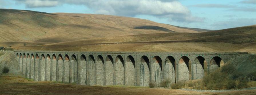 Ribblehead viaduct
How does AboutMyJourney work?
First, choose your route. Click the ‘Follow your route on a map’ button to go to the ‘The Train Routes’. Then, select the line you are travelling on by tapping either the route’s button or its symbol on the map. This will take you to a more detailed map that will show the places on your route (they may not be visible until you click the tracking button – see below). The map is zoomable, and can be expanded to full-screen mode.
Next, check your direction of travel. The map displayed assumes that you are travelling in the direction indicated by the route summary above it. If you are travelling in the opposite direction click the “Change Direction” button to display a different version of the map; it will look the same, but it will ensure that the descriptions associated with the icons are correct for your journey. Note also that “left” and “right” in the descriptions assume that you are facing forwards!
Finally, click the ![]() button to start tracking your position as you move. This will start to find your location based on either GPS or the location of the mobile network cell masts that your device is connected to. If this does not track smoothly or does not update regularly, click the
button to start tracking your position as you move. This will start to find your location based on either GPS or the location of the mobile network cell masts that your device is connected to. If this does not track smoothly or does not update regularly, click the ![]() button to make sure you are using GPS.
button to make sure you are using GPS.
Now, just enjoy the view. The blue circle shows your current location and icons on the map mark places of interest that you can see from your window or that you pass through. When you are near one, just tap the icon to get some information about it.
If GPS stops working when you are in a remote area and have no mobile signal (for example in a long tunnel) you may need to use the buttons to re-start the tracking process.
Because GPS needs a high receiver sensitivity and performs a lot of calculation, it may use up your battery charge faster than other applications.
A note about GPS and geo-location…….
Using GPS on your device will give you a very accurate and frequently updated location using the Global Positioning Satellite network. it operates by using signals from satellites to calculate your location on the ground. When you switch on your device in a new place, GPS can take some time (it can be a minute or more) to find where you are. After that, it normally updates in a few seconds, but this depends on a number of factors.
To get a GPS fix on your location, your device must be able to receive signals from a minimum of four satellites, and preferably more. In the open air, this is almost always the case. However, the signals are very weak by the time they reach you from satellites thousands of miles away (they orbit the earth at a height of around 20,000 km – 12,000 miles). The metal body of a train carriage, as well as cuttings and tall buildings (and, of course, tunnels) can block out signals, so that sometimes there might not be enough for GPS to operate.
If GPS is unavailable but your device has a mobile network connection, the geolocation system will revert to using the location of the mobile ‘phone aerial masts or wi-fi network that it is connected to. If you have signals from several masts at the same time, this can be quite accurate, but if only one is available, possibly several kilometres away from you, your location may jump from place to place as your device is handed over from one mobile mast to another, giving rise to rather odd looking behaviour as you follow your location on a map!
If GPS stops working when you are in a remote area and have no mobile signal, or if you are using a laptop or other device that has no mobile phone or data capability, then location tracking will stop altogether. Unfortunately, this is a problem that can only be fixed by train designers or network operators, not website and app developers! If it does occur for a prolonged period (2 minutes or more), you may need to use the ![]() and
and ![]()